

'Major' damage as super typhoon hits US islands
Super Typhoon Bavi struck the Northern Marianas and Guam, with authorities reporting major damage on Rota. Officials warned of dangerous winds, flooding and extended power outages.

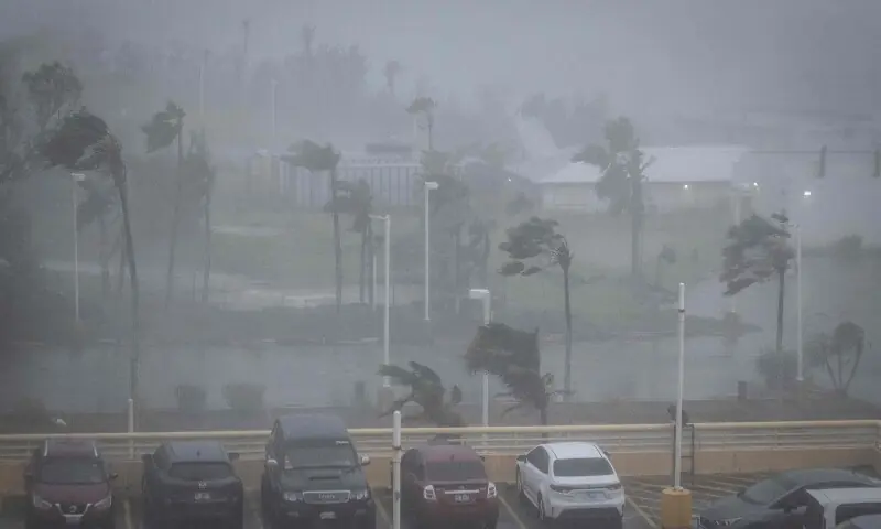
WASHINGTON: Super Typhoon Bavi swept across the US Pacific territories of the Northern Marianas and Guam on Monday, with authorities reporting major damage on the small island of Rota as powerful winds and heavy rain battered the region.
The US National Weather Service said the entire island of Rota was inside the eye of the storm, which packed winds of up to 180 miles per hour before moving slowly westward. By midday, the island group, located thousands of kilometres west of the US mainland, was still facing severe winds and intense rainfall, forcing residents to remain indoors.
Earlier in the day, the weather service urged Rota’s roughly 1,500 residents to seek immediate shelter. Local officials on the island, which lies less than 80 kilometres north of Guam, said communication problems were making it difficult to assess the full scale of the destruction. Lou Rosario, public information officer at the Rota Municipal Operations Center, said residents were dealing with flooding and strong winds and that some damage reports had already come in. Cellphone service was also disrupted after a tower fell, he added.
The National Weather Service had previously warned that a direct strike on Rota could leave much of the island uninhabitable for weeks or longer, with nearly all trees snapped and electricity outages lasting from weeks to possibly months.
Tinian, northern Guam and the southern tip of Saipan were hit by winds comparable to a category-one hurricane, according to National Weather Service meteorologist Marcus Landon Aydlett during a Facebook Live briefing. He said conditions would gradually improve as the storm moved away. The Northern Marianas and Guam together have a population of around 210,000.
Authorities on Guam had warned that the island could receive between eight and 12 inches of rain, raising the risk of flash flooding. The weather service said sustained winds of 50 to 80 mph, with gusts reaching 100 mph, were expected to continue through late afternoon, and told residents to stay sheltered because conditions remained extremely dangerous and life-threatening.
Residents across the islands described fresh disruption after an earlier storm in April. Edwin Santa Theresa, a 56-year-old health clinic worker on Tinian, said fuel supplies were likely to become a key concern because stocks were limited. He said power at his home had only been restored four days earlier after the previous typhoon, but had now failed again.
On Saipan, 61-year-old Rowell Mariano said the April storm, Super Typhoon Sinlaku, had been worse for him because its centre passed directly over the island. He said his home had been flooded during that storm and the ceiling was damaged, calling the experience traumatic.
In Guam, several hundred people took shelter at the Guam Plaza Hotel as windows shook and rainwater leaked into rooms and stairwells. General manager Sudipta Basu, 59, told AFP that about 70 per cent of those staying there were local residents riding out the storm. He said the locally owned hotel was making sure its customers had shelter and noted that it had spent $800,000 on a backup generator in April.
Across Guam and the Northern Marianas, roads were nearly empty by Sunday afternoon except for police vehicles and surfers returning from the coast. Most shops were shut, and many had boarded up their windows. Pinky Cubacub, 55, said she spent $500 on plywood to protect her eatery on Guam because she could not afford to lose too many business days.
Climate concerns
The report also cited wider climate warnings linked to storm activity. The European Union’s Copernicus Marine Service said on Wednesday that the world’s oceans recorded their hottest June on record and could see further highs in the coming months. Warmer seas can strengthen tropical storms and increase the amount of moisture that falls as heavy rain.
The World Meteorological Organisation said on Friday that El Niño had already begun in the tropical Pacific and was likely to be strong. The pattern, which usually appears every two to seven years and lasts nine to 12 months, raises surface temperatures in the central and eastern equatorial Pacific and affects wind, pressure and rainfall patterns worldwide. Aydlett said the National Weather Service was concerned that an El Niño year could make the season much busier than in the last five or six years.
Comments
No comments yet. Be the first to join the discussion!


